Read the recent thread on Kamoot…lots of good info
What if you want to simply create files of routes you already know (and love…hillbilly strade bianca anyone??) to share with your friends (vs have one built for you). Very new to this tech (like I only use paper maps ), but I think I’m looking to make a gpx file to share. What would be the best, most cost efficient platform for that?? Thanks!!!
This often depends on what country you are in as regions seem to have favorites. In the US Ride With GPS is very popular and you can get an incredible amount of functionality for free. Of course it works worldwide. If you have a ride file you can import it and create a route from it then share a link with your friends. Routes can be public or private. I know outside of the US Kamoot is very popular, but its fate remains uncertain after the recent acquisition.
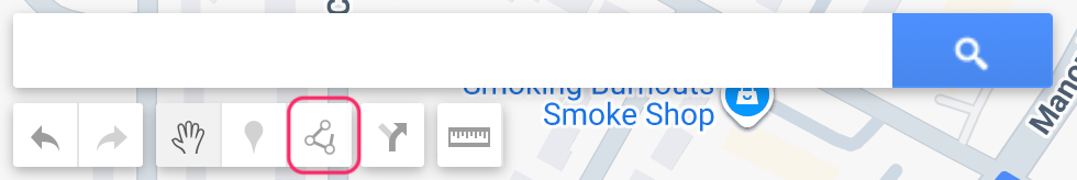
Click the one I outlined in red. That will pop up a menu with some options, including “add bike route.” So do that. Start clicking waypoints on the map. The back-arrow lets you undo. Finish a route by double-clicking the last waypoint.
You can also add points of interest (POIs) with the pinpoint icon.
Once you’ve got things looking the way you want, give the map a name and click the 3-dot menu on the left. That will show you the option to download a KML/KMZ file. You want the KML file. You can share this file however you want. Obviously you can also point people to the map online.
Note that this will not automatically include turn-by-turn directions if you want that. Google can create them internally, and other mapping software should be able to generate them from the KML file, but they don’t seem to get exported in the KML file. You could add directions as POIs, but that would be awkward.
There are a lot of different map formats. GPX is more for recording performances than directions.
Don’t Google Maps routes limit the number of POIs/checkpoints that you can have per route? Something like 10, from A - J. For routes with more checkpoints, you’d have to create additional routes, which I’ve found a little cumbersome…
Not sure if that limitation has been resolved in subsequent updates to the app though…
Argh, didn’t mean to put down your earlier comment, @adamrice and only to “Like” your subsequent one. Reading that play by play really sounds quite off-putting.
Ride with GPS fanboy here. If you have premium you can edit, correct and break it down to Garmin happy size. And you can share the files with your non paying friends.